Читайте также:
|
Methods of reservoir boundaries determination.
Abramov T.A., Skorodumov S.V., Lebedev E.S.
Tyumen State Oil and Gas University, Tyumen, Russia
genaevangel@mail.ru
The classic model of pressure behavior in well which works near the unsealing fault is solved by employing of special image well. This image well is located at the same distance from the other side of the boundary and works with same rate. The interaction of 2 wells could be described by applying of superposition. It is considered that applying of image well would give the same pressure behavior as we could receive in single well which flows near the boundary because of the same rates we’ve got no fluid flowing through the boundary.
The pressure build-up behavior could be also described by the applying of superposition. Equation of this superposition drawn in Horner plot gives the double-multiplied slope of build-up line of the late time in relation to the early time line. The distance to the boundary could be calculated by the equation:
 , (1)
, (1)
where tx - the time of the intersection of the early and late times
Our calculations put in the main equation of the build-up shows an inexactness of the method of images. In our example we put the distance of 10 meters in the main equation of superposition of build-up and after that we drawn it in Horner plot. The time of intersection yielded the distance of 22,7 meters, which is larger more than in two times than initial. It could be described like that. In fig. 1 showed the depression surface of complex kind which yielded by the interaction of 2 wells – real and image (shown by the red line). But the functions describing processes after shut-in do not take into account the formation of complex surface and suit only to the single well. Consequently we offer a new more accurate calculation of the distance to the boundary based on new model of well producing next to the fault.
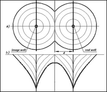
Fig. Formation of complex depression surface.
Seismic criteria for predicting reservoir quality and delineating complex traps in oxfordian sands of the West Siberian petroleum province
Kontorovich D.V.
A.A. Trofimuk Institute of Petroleum Geology and Geophysics SB RAS, Novosibirsk, Russia
clay@ngs.ru
Introduction
In the West Siberian petroleum province, common deep point (CDP) seismic reflection survey is the basic geophysical technique for prospecting and preparing oil and gas trap for deep drilling as well as for delineating the field outlines. The large amount of seismic exploration conducted during the past decade of the XXth century enabled the majority of medium- and high-amplitude traps to be revealed in West Siberia. Exploration for hydrocarbons showed that the major hydrocarbon pools found in Jurassic and Lower Cretaceous deposits have not only the structural but also lithological, tectonic and stratigraphic control. As predicted by geologists, the traps controlled by lithology and faults are likely to contain 30% of the forecast hydrocarbon resources.
Delineation of such exploration targets will require mapping the reservoir facies changes to impermeable rocks and conducting the quantitative permeability and porosity estimation.
In southeastern West Siberia the majority of hydrocarbon resources and reserves are associated with the Oxfordian reservoir, J1 horizon, Vasyugan Formation. Considered in the present study are the techniques that allow the reservoirs to be delineated and mapped using a combination of geophysical logging and deep drilling data. The field data are presented in the 2D CDP-time cross sections and in the well logs.
Дата добавления: 2015-10-29; просмотров: 136 | Нарушение авторских прав
| <== предыдущая страница | | | следующая страница ==> |
| Biomarkers in organic matter of Jurassic deposits in the western part of the Yenisei-Khatanga regional trough, Russia | | | Seismic stratigraphy, tectonic history and petroleum potential of the northern part of Kaymysovsky vault |