Читайте также:
|
Besides being for centuries a very important oracle seat, the Didymaion was also renowned for its sacred water, sacred grove, the many sacred elements it housed, and its wealth. The riches of the temple had its source in donations and votive offerings made in varying forms. The very valuable offerings of King Necho of Egypt, King Croesus of Lydia and King Seleucus II of Pergamum, had an important place among the donations made to the Didymaion. The donation of various sacrificial animals, 1,000 in number, and 12 rams by Lysimachus, was also one of the interesting offerings.The fact that Miletus attempted to build a fleet with the treasury of the temple before the battle of Lade, shows how rich the Didymaion was.
One other feature of the Didymaion was that it had the right to shelter. This right which was termed "the Right of Asylum", was the recognition of the right of inviolability to people who took refuge in the temple. The right of asylum, which therefore created many problems, had given rise to many a discussion. The boundaries of the right of asylum, however, were gradually enlarged and were increased to 3 kilometers by Emperor Augustus Trajan enlarged the boundaries even more and wanted them to be recognized from the beginning of the Sacred Road.
It is understood from inscriptions that the festivities and ceremonies held every year in spring went on even after the Didymaion was completely destroyed in 494 BC. The journey from Miletus to the Didymaion was made by sea or by the Sacred Road. The group of people who set out from Miletus with ceremonies begun in the Delphinion where they received the sanctification of Apollo and were sent forward by the Delphins, came from the Lions' Harbour to the Panarmos Harbour, and from there reached the Didymaion on foot. First, sacrificial beasts and votive offerings were presented to the god, then, after ceremonies to the accompaniment of music and chorus, the important persons entered the temple, and after that, the questions asked by inquires were answered by the oracle. The ceremonies were directed by the Stephanephors. It was shown by inscriptions that the Emperors Augustus and Trajan took the title of Stephanephor and carried out this position. In the Roman period, the Sacred Road gained in importance as the harbors filled up with alluvial mud and travel by sea became unfeasible.The reason for this extremely impressive and magnificent temple's not being considered among the seven wonders of the world is related by the authorities to its not having been completed.
Citadel, City Walls and Gates of Diyarbakir

Situated on the banks of Tigris (Dicle) river in South-Eastern Anatolia, Diyarbakir still carries a medieval air with its walls encircling the city.
Starting from the earliest times, the city was ruled by the Hurri -Mithani, Hittites and Assyrians. It was once the capital city of the Arami Bit-Zamani Kingdom. It was later occupied or ruled by the Meds, Persians, Macedonians, Seleukos, Romans, the Ilkhanide and the Akkoyunlu Seljuks. It is referred to as Amidi, Amid, Amido or Amida in different sources. In Islamic - Arabic sources it is cited as "Diyar-i Berk". In the republican era it is started to be known as Diyarbakir deriving from the copper ore existing in the area.
The city walls of Diyarbakir are more than five kilometers long, among the longest of medieval fortifications; only the Great Wall of China is longer. It is constructed of imposing masonry in black basalt (a stone of local origin), and had along its circuit more than 75 towers, all but six of which are still standing. There are four original gates in the wall, the Harput gate in the north, the Yeni Kapi in the east, the Mardin gate to the south, and the Urfa gate to the west. The citadel of Diyarbakir is on a hill in the northeast corner of the wall, defended by its own ring wall built during the Ottoman period.
These black basalt walls are perfect examples of the military architecture of the Middle Ages. They are also very well known since they are the second largest (5.5 kilometers) and best preserved walls in the world after the famous Great Wall of China. Although there were Roman, and probably earlier walls here, the present walls date back to early Byzantine times. There are sixteen keeps and five gates, each of which deserves seeing along with their inscriptions and relief. There are four main gates along the wall called as Dag Kapi, Urfa Kapi, Mardin Kapi and Yeni Kapi, and they open to four different directions. The walls are 12 meters high, 3-5 meters wide and have 82 watchtowers.
The location of the gates and the line of the wall dates from the late fourth century A.D. A north-south street connects the Mardin Gate with the Harput Gate; an east-west street connects the Urfa Gate with the Yeni Kapi. The central market is at the intersection of these main avenues. Although some Byzantine stonework is incorporated into the fortifications as we see them today, the late Roman walls were largely repaired or replaced piecemeal in Medieval times, in 909 by the Abbasid caliph Al Muktadir, and substantially during Diyarbakir's rise in prominence between the eleventh and thirteenth centuries.
Al Muktadir rebuilt the Harput gate and the Mardin gate following their intentional demolition by his predecessor ten years earlier. The Harput gate is a Byzantine design embellished during the rebuilding with crude animals carved in relief. The entrance, as are all gates, is heavily fortified between two half-round towers that project almost 15 meters from the line of the wall. The Mardin gate is similar in plan and decoration. Carved fauna became a tradition among subsequent rebuilders of Diyarbakir's towers and walls.
Sultan Malik Shah of the Great Seljuks built four towers on the western wall, celebrated in floriated Kufic inscriptions. One of these inscriptions, on a tower dated 1088, has a figural carving in the center of the dedication featuring a seated man flanked by two bulls, while at each end of the writing a lion is carved above a ram and an eagle with outstretched wings. Another similar tower, built in 1089, has carvings of a seated man with galloping horses at his sides above the inscription, and lions with knotted tails at each end of the first line. These are followed by hares facing each other and an eagle above a seated female nude.
In 1183 Diyarbakir became the capital city of the Artukids, who made the most significant additions to the walls. That year the Urfa Gate was rebuilt by the Muhammad, son of Kara Arslan. The gate has finely carved figures of dragons on either side of an inscription, and on the keystone of the arched gate is a bull's head surmounted by an eagle with outstretched wings. In the same area of the western wall, south of the gate, are the two most imposing towers, Ulu Beden and Yedi Kardes. Both were commissioned in 1208 by the Artukid al-Malik al-Salih Mahmud (who designed the Yedi Kardes tower himself). The Ulu Beden tower was built by the architect Ibrahim bin Jafar; Yedi Kardes was constructed by the architect Yahya bin Ibrahim Sufi. The Ulu Beden tower is almost a full circle in plan, as it defends a sharply acute angle in the walls. It is 25.5 meters in diameter, faced with smooth basalt, and encircled midway up its height by a monumental inscription. The bulk of the inscription is one line of Kufic script, but in the center there are three lines forming a rectangular focal point. Winged, human-headed lions decorate the top two corners of the plaque; the bottom corners are each decorated with bulls. In the center above the inscription is the Artukid double-headed eagle. The Yedi Kardes tower is similar in all respects to the Ulu Beden tower, but it is slightly larger, 27.8 meters in diameter.
By the early thirteenth century the fortifications were strong and needed few additions. The Ottomans expanded the internal wall that separated the citadel from the rest of the city in the sixteenth century, but by then they had abandoned the fashion of decorating the construction.
The citadel was fortified in the east by the city wall, and separated from the city by an additional wall on the west. In the early thirteenth century, during the Artukid period, the fortifications enclosed administrative buildings; the area still functions much the same today. Just outside the thirteenth century walls is the Kale Mosque, built in 1160. Its position compromises the security of the walls (which were built later). Also within the citadel is the Artukid palace that was used as a prison by the Ottomans.
The most famous structure which witness to the rich historical heritage of Diyarbakir is its fortress. This fortress located on a solid rock called "Fis" 100 meters high from the Tigris (Dicle) river is believed to be built by the Hurri. The citadel has a domed basilica (a Nasturian Church from the 6th century), a mosque, Sahabeler tomb, an Artuklu Palace and some old official buildings.
Another structure that is rich in historical heritage is the fortress (built by the Hurris), which stands on a solid rock called “Fis”. This citadel is 100m high from the Tigris River and contains a domed Basilica, a mosque, Sahabeler tomb, a palace and some official buildings.
Other places of historical importance include the Mesudiye medrese, Hasan Pasha -han, the Nebii mosque, Kasim Padisah mosque (contains the Dort Ayakli Minaret), the Antak city ruins, the Birkleyn and Hasun caves and the Syriac orthodox church of Lady Meryemana (was originally a Pagan temple).
Another important site is the house of Cahit Sitki Taranci, the most celebrated poet of the republican period, which has been turned into a museum in 1973.
Apart from these, you can come to the famous Malabadi Bridge on Diyarbakir-Batman provincial border, which is an Artuklu Seljuk structure. Among all the arch bridges in the world, Malabadi possesses the widest arch width.
The bridge is near Silvan, a district of Diyarbakir, on Diyarbakir - Batman provincial border. It is a magnificent Artuklu Seljuk piece which witnessed so many events and is a must-see spot for any tour passing from the area. It has the widest arch width among all arch bridges in the world. It connects two banks of the stream not on a straight but broken line. Evliya Celebi, a well known Ottoman traveler says the following about the bridge: "The bridge has iron gates on both sides. There are hostels in these gates, to the right and to the left, and also under the arch. While some chat, others fish by throwing their nets down to the Batman Brook.". The inscription on the bridge gives the date of construction as 1147-1148. The inscription also reveals that the bridge was built by Timurtas, the ruler of the Artuklu in Mardin.
the Deliler Han (Inn) by the Mardin Kapi of the City Walls was built by Husrev Pasha in 1527 and also known by his name. Now it is restored as a hotel with 120 beds preserving the original air of the old days when caravan travelers on the silk road used to stop and rest in this caravanserai. It is a two part structure, a two storey main part and a stable. The local people call it "deliler" (guides) since guides who took pilgrims from various locations to Mecca each year used to gather here. The remains existing just across the inn are also attributed to pilgrims.
Another fascinating sight in the city center is the Ulu Mosque, notable for its original architecture and the ancient materials used in the restoration of the building at various times. It is one of the oldest mosques in Turkey. It is known that the Church of Saint Thomas was gradually converted into a mosque. It is a grand and impressive structure, built of cut stone over an area of 80 x 80 meters. The minaret behind the mosque is rectangular. Its fountain (1849), carved marbles and niche are all important artworks. The walls of the mosque are also ornamented with relieves and carvings. The minaret and the gate bear 20 inscriptions dating back to various periods in history. The tombs in the courtyard was destroyed by the Persian King Ismail in 1507.
Nearby the Ulu Mosque is the Mesudiye Medrese and Hasan Pasha Han, a caravanserai now being used by carpet and souvenir shops. The Nebii Mosque is a typical example of the Ottoman style. The Church of the Virgin Mary is interesting and it is still in use (not to be confused with the one in Ephesus).
The Kasim Padisah Mosque is also interesting, especially due to the engineering which built a large tower upon four tiny pillars about two meters (6.5 ft) high, called the Dort Ayakli Minare (minaret).
The location of noted mythological cave Eshab-ul Keyf, and Dacianus ruins are in the town of Lice. The holy Mount Zulkufil and Hilar Caves are in the town of Ergani. Within the environs of Diyarbakir are the Birkleyn and Hasun Caves, the Antak City ruins and the Cayonu Archaeological Site.
The city holds many mosques and buildings of long historical and archaeological importance. There are four museums in the city center. When you add to those the renowned watermelons of about 40 kilograms (85 lb) approximately, and its silver and copper artifacts, Diyarbakir certainly stands as a destination to be visited in Anatolia.
The house where Cahit Sitki Taranci, one of the most celebrated poets of the Republican period, was born was turned into a museum in 1973. The museum exhibits the photographs and personal articles of the poet as well as some ethnographic pieces obtained from the area. The house bears the characteristic features of local architecture.
Gazi Kцskь is a nice place for picnicking. The town of Cermik is a spa center.
Jewelery, silk processing, coppersmith works, pottery, leather works, felt making, textiles, embroidery and carpet making are the leading handicrafts in Diyarbakir. Among them, jewelery is still important. Mat bracelets, coriander, necklaces and silver ornamented wooden shoes are the special works of the province. Sericulture is practiced at the city centre and in the districts of Kulp, Silvan and Lice. However, silk production is in decline. Textiles which lived its golden age in the 40s now survive only in small workshops.
ЭЬьEPHESUS
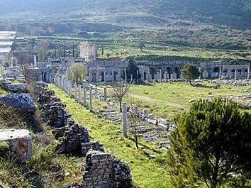
According to tradition, Efes (Ephesus), one of the most important cities of antiquity, was founded by Androclos, although it has been established that the Lelegians and Carians inhabited the place earlier. The city must have been colonized no later than the 10th century B.C., by the lonians. Then Persian invasion in the 6th century B.C. took place. As you can see Ephesus History goes way back. This was followed by Ionian uprising against the Persians during the 5th century B.C. The ruins remaining are of the city established by Lyssimachos, one of the generals of Alexander the Great in the 3rd century B.C. The best remains of the city ramparts today are from this era. During its Golden Age (2nd century B.C.), the city had a population of around 300,000; it monopolized the wealth of the Middle East and was one of the principal ports of the Mediterranean. Finally, the Roman and Byzantine Empires took control of the city. When the Seljuks and later Ottomans claimed the control of the city, it had already lost its commercial and political significance. Today, a visit to Ephesus is one of the highlights of any visit to Turkey
эЬьVisits to the ruins of Efes usually begin in the eastern part of the city through the Magnesia Gate, around the important Upper Agora or also known as the State Agora. The Eastern Gymnasium is located just next to the Magnesia Gate on the Pion mountain side. Clustered around the State Agora were the Varius Baths and the Odeion, both from the 2nd century A.D., the Prythaneion or Town Hall, and the Temple of Domitian - the first temple of Efes to be built in the name of an emperor (81 - 96A.D.) - located next to the Domitian Square. The Temple of Dea Roma was located right next to the Odeion.
Leading westwards from the Upper Agora is the famous Curettes Street. Of particular interest on the eastern part of the street are the Pollio (4th century A.D.) and Traian (2nd century A.D.) Fountains, the Memmius Monument (1st. century A.D.), the elegant facade of the Temple of Hadrianus, the Skolasticia Baths (2nd cent. A.D.), and the Heracles Gate. Set on the hillside above the street are the restored Terraced Houses, containing interesting, often well preserved frescoes from the 2nd century A.D.
At the start of the Marble Street (built by Nero, 54-68 A.D.) is the Lower Agora. Just to the left as one approaches the agora, is the Celsus Library (2nd century A.D.) with its very elaborate facade, which has been restored. The Gate of Mazaeus and Mithridates has been restored and is the most beautiful entrance to the Agora. One of the most interesting buildings in Ephesus, the Serapis Temple, is located right to the west of the Agora. St. Paul gave sermons in the Grand Theatre, seating 25,000 - the most spectacular monument of Efes. The Theatre beautifully restored and now serves as a setting for the artistic and folkloric shows of the international Efes Festival, held every year in spring. The Theatre Gymnasium, opposite, built in the 2nd century A.D., also contained a bath-house.
The Arcadian Way was the long main road, paved with marble and lined with columns on both sides, that stretched from the Grand Theatre to the old port, now totally silted. On this road was the Four Evangelists Monument - four columns upon which stood statues of the four evangelists. The marvelous Hellenistic Fountain stood just across the Theater and next to the eastern end of the Arcadian Way. I love Ephesus History.
The Vedius Gymnasium was located to the north end of the city, right next to the Byzantine era city ramparts. The oval shaped stadium was built during the time of Emperor Neron and located to the south of the Vedius Gymnasium. There was also a love house behind the Hadrianus Temple.
Down by the ancient harbour is the Harbour Gymnasium and Baths. These were constructed near the quay in order to receive with hospitality dignitaries who arrived from the sea.
The Church of the Holy Virgin Mary was constructed in the 2nd and 3rd centuries, and it played an important role in the early expansion of Christianity; this church symbolized one of seven Churches of the Apocalypse.
The cave of the Seven Sleepers is reached through the asphalt road which goes through the east of the Vedius Gymnasium.
эЬьNearby is the House of the Virgin Mary. According to tradition, St. John brought Mary to Efes after the death of Christ. A small house was built for her on Bulbuldagi (Mt. Nightingale) where she spent the last days of her life. Officially sanctioned by the Vatican, it is now popular site of pilgrimage, visited by Christians and Muslims from all over the world. A commemoration ceremony is held here every year on the 15th of August.
On the road from Efes to Selcuk is the ruin of the Temple of Artemis. Once numbered amongst the Seven Wonders of the ancient world, it was constructed entirely of marble. The marble road which was connecting the Temple of Artemis to the State Agora through the Magnesia Gate was considered to be the holy road of the city.
The town of Selcuk is dominated by a Byzantine citadel overlooking the Basilica of St.John (presently under restoration). The present structure was built by the Emperor Justinian in the 6th century A.D. St.John lived on this hilltop and was buried here. Next to the Basilica is the Isa Bey Mosque with its typical Seljuk-style portal. It is one of the finest major works representing Seljuk art.
The first excavations of the ancient city of Ephesus was started in the late 19th century.
The Efes Archaeological Museum in Selcuk has been enlarged and displays now the impressive works of art recovered from and around Efes.
эЬьTHE MAGNESIA GATE
The road connecting two important centers of the region Ephesus and Magnesia (today called Manisa) entered into the city through this gate. It was built in the 3rd century B.C. (Hellenistic Age) together with the city ramparts. The excavations are still going on.
During the Roman peace period the gate lost its strategic importance. Roman emperor Vespasianus (69 - 79 A.D.) changed the name of the gate to "The Gate of Honor" and added two more entrances to the gate with and arched look.
There were square shaped towers on both sides of the gate and a courtyard on the city side. If the attackers achieved to break into the gate, they would still be confined into the courtyard which was separated from the city by a second gate for the security reasons. This way the attackers would be trapped and destroyed much easily.
There are tombs in the square which was made of big gray stones in front of the courtyard and the gate. These must have been belonging to the important citizens of the city.
During the late Roman age they built a water canal to the east of this square.
This famous road reaches to Magnesia on one end and to the Artemis temple through to the hills on the other end. It turns back to the city side and connects to the Magnesia Gate.
The road had been repaired during the 2nd century A.D. (Roman period). Although the city seen today was built according to the plans of Miletian architect Hippodamus, this road was not changed because of its sacred nature. The contradiction can easily be seen as you notice the city streets are all perpendicular to each other while this road consists of many curves along the way.
Дата добавления: 2015-10-29; просмотров: 132 | Нарушение авторских прав
| <== предыдущая страница | | | следующая страница ==> |
| THE HELLENISTIC DIDYMAION | | | THE STATE AGORA |