Читайте также:
|
To study hard-to-reach places, scientists in Antarctica are relying on remote-controlled planes, including those from the hobby shop.
By Davide Castelvecchi
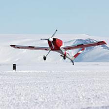 Unmanned aircraft for polar science, such as the Meridian (shown during a test flight in Antarctica), are less expensive and safer to operate than ordinary airplanes. Image: Courtesy of University of Kansas Aerospace Engineering Flight Test Team
A multinational, robotic air corps is quietly invading the polar regions of the earth. Some catapult from ships; some launch from running pickup trucks; and some take off the old-fashioned way, from icy airstrips. The aircraft range from remote-controlled propeller planes—of the type found at Toys “R” Us—to sophisticated, high-altitude jets. All are specially outfitted, not with weapons but with scientific instruments.
Unmanned aircraft have made headlines in the mountains of Afghanistan, but the technology has quickly trickled down to scientists seeking a less expensive, safer way to study the earth’s poles. Researchers have begun to put unmanned aerial systems, or UASs, to a variety of tasks, from monitoring the ozone layer to counting seal populations. Thanks to lower costs and improved technologies, “it’s absolutely exploded in the past couple of years,” says Elizabeth Weatherhead, who is an environmental scientist at the University of Colorado at Boulder.
The planes can be loaded with a variety of instruments, from radar (or lidar, the laser-based version) to chemical analysis tools and infrared sensors; some simply carry cameras. Last summer Weatherhead counted at least six different teams of scientists using UASs on a single Norwegian island. Her own group used a converted reconnaissance drone in two different Greenland missions. One mission was to count ice seal populations; another was to map melt ponds to help explain “why the edges of Greenland are melting so quickly,” she says. The team’s small UAS surveyed two melt ponds in a few days, Weatherhead says. “That’s something that previously would have taken researchers weeks for a single lake.”
Many of the aircraft cost several millions of dollars and are not exactly expendable. But at least if one goes down, there’s no loss of human life: polar crashes are “often beyond rescue capabilities,” Weatherhead says.
Some teams have learned to design and build their own aircraft. Richard Hale of the University of Kansas’s Center for Remote Sensing of Ice Sheets was in Antarctica this austral summer to test the Meridian, a new, single-prop unmanned plane built by a team mostly of Kansas students. The half-ton UAS, with a wingspan of eight meters and a range of 1,750 kilometers, will conduct radar surveys of the ice masses and of the underlying land.
Many of the planes fly preprogrammed routes by autopilot and are only remotely controlled for takeoff and landing (although some small ones are clotheslined by a strong wire). Small UASs are fuel-efficient, which is especially important in a place like Antarctica, where all the fuel has to be flown in at great expense. “We burn 1/20th of the fuel” of a conventional airplane, Hale said in January, speaking over a satellite link from the National Science Foundation’s McMurdo Station.
In an age of constant satellite surveys, airplanes are still necessary. They can, for example, “map the ice sheet at a resolution that modelers can use to really understand the dangers we’re seeing,” explains atmospheric scientist David Braaten of the University of Kansas. Braaten was a member of a team last year that mapped the Gamburtsev Mountains in Antarctica, a chain the size of the Alps buried under thousands of meters of ice. That survey was done with radar mounted on an ordinary twin-engine propeller airplane based in East Antarctica. (Robin Bell of Columbia University’s Lamont-Doherty Earth Observatory chronicled the effort in her blog on ScientificAmerican.com.) If a UAS had been available at the time, that project might have been “a lot cheaper,” Braaten figures.
Even better, a UAS with a long enough range could survey Antarctica while being based in Chile. This possibility may actually become true in the next few years. In October, NASA conducted the first test flights of its newly acquired Northrop Grumman RQ-4 Global Hawk, a jet-powered drone that can fly at altitudes up to 65,000 feet (where it can avoid the rough weather of polar regions) for more than 31 hours at a time. It can literally fly to the other end of the earth on a single tank of fuel.
The agency hopes to start science missions in March. NASA atmospheric physicist Paul Newman says the drone’s first task will be to help the agency calibrate satellite measurements of the ozone layer. “We’ll also have a number of instruments that measure aerosols,” Newman adds. “We’ll use this to estimate the cross-Pacific transport of air pollution and aerosols.” No doubt, robot aircraft for science are really taking off.
Дата добавления: 2015-10-23; просмотров: 74 | Нарушение авторских прав
| <== предыдущая страница | | | следующая страница ==> |
| Саша, готовься, теперь тебе не жить»- по пути в ванную похлопала подругу я по плечу. | | | Течение и ведение I периода родов – периода раскрытия |