Читайте также:
|

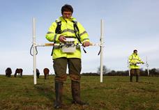
Magnetometer Magnetic gradiometer survey
In common with gravitational methods, magnetic prospecting utilizes a natural and spontaneous field of force, with fields of geologic bodies superimposed upon a normal terrestrial field. The gravitational fields of geologic bodies do not depend on the earth’s gravitational field, whereas magnetic bodies frequently owe their magnetization to the magnetic field of the earth. For this reason, magnetic anomalies are often subject to change with latitude. Moreover, rocks may have magnetism of their own whose direction may or may not coincide with that induced by the terrestrial magnetic field. An important factor in the interpretation of magnetic methods is that rock magnetism, contrary to rock density, is of a bipolar nature.
In gravity methods, total field vector and the horizontal gradients of the vector or of its horizontal components, are observed. In magnetic prospecting, measuring of the total vector are the exception rather than the rule; it is usually resolved into its horizontal and vertical components. Experience has shown that the vertical component exhibits the clearest relation between magnetic anomalies and disposition of geologic clearest bodies, at least in northern and intermediate magnetic latitudes. Therefore, measurements of the magnetic vertical intensity are preferred and are supplemented occasionally by horizontal intensity observations for greater completeness in the evaluation of the anomalies.
Magnetic fields are generally expressed in gauss (simplest definition is lines per square centimeter – in air); in magnetic exploration it is more convenient to use 1/100,000 part of this unit, called the gamma (γ). The accuracy requirements in magnetic prospecting are less than gravity work; it is a comparatively easy matter to design instruments suitable for magnetic exploration.
The magnetic anomalies of geologic bodies are dependent on their magnetic “susceptibility” and “remanent” magnetism, properties which vary much more widely than their densities. Rocks and formations fall into two natural groups: igneous rocks and iron ores are strongly magnetic whereas sedimentary rocks are generally weak in magnetization. The magnetic characteristics of rocks are affected by numerous factors such as: magnetic content, grain size, lightning, heat, contact metamorphism, mechanical stresses, disintegration and concentration, and also by structural forces which may alter the disposition of magnetic formations in the course of geologic periods.
Most widely used in magnetic prospecting are the Schmidt magnetometers. There can be Schmidt vertical intensity magnetometer and Schmidt horizontal magnetometer. These instruments provide the high degree of accuracy required in oil exploration.
The following corrections are required in magnetic exploration: (1) correction for temperature of instrument, arising from the fact that the magnets used for comparison with the earth’s magnetic field lose their strength with an increase in temperature; (2) a “base” correction which allows for errors of closure when checking back to a base station; (3) a correction for daily variation which may be determined by visual observation or recording of a second magnetometer; (4) a planetary correction, which eliminates the normal variations of the earth’s magnetic field with latitude.
Fences, bridges, pipe lines, derricks, well casings, and the like, are a serious handicap to magnetic exploration and must be kept at sufficient distance, as it is difficult to correct for them.
Magnetic results are generally represented in the form of lines of equal magnetic anomaly (“isanomalic” lines – the name “isogams” as applied to magnetic lines is a misnomer) or in the form of curves for profiles at right angles to the angles to the assumed strike. Interpretation of magnetic anomalies is usually qualitative. In the interpretation of magnetic data in oil exploration, magnetic anomalies ranging from fifty to several hundred gammas may be assumed to result from variations in topography and composition of igneous rocks or from igneous intrusions.
In quantitative interpretation magnetic effects of assumed bodies are calculated, compared with the field curves, and assumptions changed until a geologically reasonable agreement is obtained. Direct methods of interpretation are applicable when the magnetic anomaly is simple and arises from one geologic body only; in that case, approximate calculations of depth may be made directly from the anomaly curves by assuming that the magnetic bodies are equivalent to single poles, magnetic doublets, single magnetized lines, and line doublets.
(C.A. Heiland. Geophysical Exploration. New York, 1940)
35. Which words from your active vocabulary are given here?
_ _ I _ _ I _ _
_ _ _ N _ A _ _ _ __ _
_ _ _ U _ _
_ _ I _ E _ _ _ _
_ _ P _ _ _ _ E_ _
_ _ _ _ _ S _ _ I _ _
_ _ _ _I _ A _ _
_ _ P _ _ _ _ _O _ _ _
Дата добавления: 2015-10-26; просмотров: 144 | Нарушение авторских прав
| <== предыдущая страница | | | следующая страница ==> |
| Using the diagram describe the general principle of gravity survey. | | | Give the explanation to the following diagram. |