|
Читайте также: |
At present the greatest use of geophysical prospecting is made in oil exploration. The three principle geophysical methods used in petroleum exploration are seismic, magnetic, and gravity. The magnetic method is the oldest geophysical method, and is based on the measurement of variations in the magnetic field due to changes of structure or magnetic susceptibility of the rocks. Sedimentary rocks generally have a smaller susceptibility than igneous or metamorphic rocks, so an interpretation of the recorded anomalies can yield the maximum depth value for a sedimentary basin. Today, magnetic surveys for hydrocarbon exploration are usually carried out from the air (aeromagnetics) or from a ship. The gravity method is based on the measurements of the variations in the pull of gravity from the rocks in the upper layers of the earth's surface. Denser rocks have greater gravitational attraction than less dense rocks. For example, a structural uplift of denser rock will appear as an anomaly on the gravity map. Gravity surveys for hydrocarbons are carried out on land, in the air on helicopters, and at sea on ships.
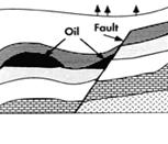 Petroleum deposits near fault
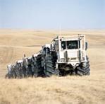 Vibroseis trucks
The most widely used geophysical method is the seismic method. Exploration seismology is divided into the branches of reflection seismology and refraction seismology. Most petroleum exploration is done by the reflection seismic method. Reflection seismology is a method of mapping the subsurface sedimentary rock layers from measurements of the arrival times of events reflected from the subsurface layers. The technology of collecting and processing reflection seismic data is based on a fundamental concept by generating seismic energy which penetrates the earth's surface. Basically, the concept is the same for both land and marine surveys.
 Aircraft for remote sensing
On land, seismic energy is generated at or near the earth's surface by arrays of small chemical explosions, or vibrating machines, or thumping devices. The seismic waves resulting from the downward propagation of this source energy are reflected from the various interfaces and received by the detectors. A central recording unit then digitizes the analog signals and records them for subsequent analysis. At sea, a source such as an array of air guns is actuated every few seconds as the ship moves over a predetermined course. The seismic waves are picked up by detectors embedded in a cable (called a streamer) trailing the ship. As in land surveys, the data is transmitted to a central recording unit and recorded in digital form.
(M. T. Sylvia, E.A. Robinson. Deconvolution of Geophysical Time Series in
Дата добавления: 2015-10-26; просмотров: 119 | Нарушение авторских прав
| <== предыдущая страница | | | следующая страница ==> |
| Read the following expressions and equations. | | | Using the diagram describe the general principle of gravity survey. |